Physical Expansion of the University
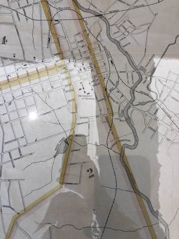
Athens, GA began to take shape in 1801, when Clarke County was enacted, named for war hero Elijah Clarke. Athens was named for the classical city in Greece, Athens, because of its passion for higher education and learning. Athens was built around the new institute of higher learning, the University of Georgia. The city’s growth was spurred on by the emerging cotton and logging industries around the area. During the Civil War, Athens became an important supply center for the Confederacy, when the New Orleans armory was relocated to the small town; the town was not destroyed during Sherman’s March, however. During Reconstruction, the city began to expand because of emerging railroad lines, many of which are still in the ground today. The university’s enrollment, however, did not increase substantially during this time. This was due to the restrictions on enrollment, being that women and people of color were not being admitted, and the cost of attending the college was astronomical for most at the time. In fact, enrollment at UGA did not get into the thousands until 1919, when women were first admitted. The map above, drawn in 1893, shows a well-developed downtown Athens, while the entirety of the South Campus of UGA was not even in existence yet. Popular, modern sites such as Sanford Stadium and the steps leading down to the area were years away from being built. However, because of the future changes in Georgia history such as the Civil Rights Movement and the development of the HOPE scholarship, the University of Georgia would become the flagship institution for the Empire State of the South.
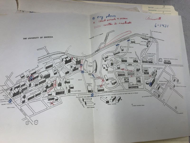
After the nineteenth century, rapid changes came about for the university. In 1906, the first building on South Campus, Conner Hall, was opened for the College of Agriculture; thereafter, South Campus gained the nickname “Ag Hill”, which still persists today. The integration of women in 1918 brought about the construction of Soule Hall, the first female dormitory, in 1920 and Dawson Hall, the first instructional hall solely for women, in 1932. The campus continued to grow around other buildings in South Campus; Mary Lyndon Hall and Rutherford Hall were finished by 1939 and Myers Quad soon became a hub of student activity (Dendy 86). More academic buildings were built and by 1961, South Campus had gained a Chemistry, Physics, Biology and Food Sciences building because of increased state funding into the sciences. Other structures built between 1893 and 1961 include Sanford Stadium, opened in 1929, and the Georgia Center for Continuing Education, opened in 1957. It is easily seen in the map that South Campus had become the center for education at UGA, since many dormitories and dining halls had taken up residence in the area. North Campus had been largely filled by 1961 by additions such as Park Hall and Joe Brown Hall, so building had been slowed by then. The development of South Campus really shows the progression of UGA from a finishing school to a legitimate, accredited university, though the HOPE scholarship would bring about higher SAT scores from incoming students and even better state funding for scientific research programs.
Sources
Dendy, Larry B. Through the Arch: an Illustrated Guide to the University of Georgia Campus. The University of Georgia Press, 2013.
Dyer, Thomas G. The University of Georgia: a Bicentennial History. University of Georgia Press, 1985.
Lowe, Jo A, editor. University of Georgia Fact Book. 24th ed., The University of Georgia, 1993.


