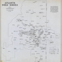
Map of Atlanta Public Schools 1958
Dublin Core
Title
Map of Atlanta Public Schools 1958
Subject
Atlanta Public Schools
Description
This map shows all of the locations of the public schools in Atlanta in 1958
Creator
Atlanta-Fulton County Joint Planning Board
Publisher
Georgia State University Digital Library
Date
1958
Rights
Property of the Georgia State University Library. The City of Atlanta may own copyrights in this item under Title 17 of the U.S. Copyright Law. To the extent the City of Atlanta may own such copyright, the city has granted GSU Library a non-exclusive license to digitally display these materials. The City of Atlanta does not attest to the accuracy of this image. The contents of this item, including all images and text, are for personal, educational and non-commercial use only.
Format
Still Image
Language
English
Type
Map
Coverage
Atlanta City Limits
Still Image Item Type Metadata
Original Format
Map
Physical Dimensions
105 W x 119 L
Scale: 1:24000
Scale: 1:24000
Files
Collection
Citation
Atlanta-Fulton County Joint Planning Board, “Map of Atlanta Public Schools 1958,” Mapping Nature — Fall 2018 ENGL1102 Composition, accessed September 22, 2024, https://sarus-sapien.net/fall2018-omeka/items/show/236.
