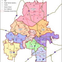
Map of Atlanta Public Schools 2018
Dublin Core
Title
Map of Atlanta Public Schools 2018
Subject
Atlanta Public Schools
Description
This map shows the locations of all the public schools in the APS system in the year 2018. Each symbol represents a elementary, middle, or high school in the city limits.
Creator
Atlanta Public School System
Publisher
Atlanta Public School System
Date
2018
Rights
No known rights held over this resource.
Format
Map
Language
English
Type
Image
Coverage
Atlanta City Limits
Still Image Item Type Metadata
Original Format
Map
Files
Collection
Citation
Atlanta Public School System, “Map of Atlanta Public Schools 2018,” Mapping Nature — Fall 2018 ENGL1102 Composition, accessed September 22, 2024, https://sarus-sapien.net/fall2018-omeka/items/show/79.
