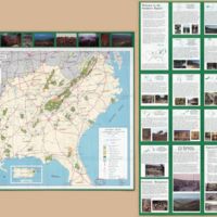
A guide to your national forests, southern region
Dublin Core
Title
A guide to your national forests, southern region
Subject
Forests reserves--Southern States--Maps
Description
Panel title: A guide to your southern region national forests : the national forests, America's great outdoors. "Constructed by automated methods in 1994 in the Regional Office, U.S. Forest Service, Atlanta, Georgia, from USGS 1:2,000,000 DLG data, dated 1983. Press plates constructed ... at the U.S.F.S. Geometronics Service Center, Salt Lake City, Utah." Includes inset of Purto Rico and coverage diagram. Text, maps, and col. ill. on verso. Available also through the Library of Congress Web site as a raster image.
Creator
United States. Forest Service. Southern Region.
Geometronics Service Center (U.S.)
Geometronics Service Center (U.S.)
Source
Library of Congress
Publisher
Geometronics Service Center (U.S.)
Date
[Atlanta, Ga.] : The Region, 1994
Contributor
United States. Forest Service. Southern Region.
Rights
The maps in the Map Collections materials were either published prior to 1922, produced by the United States government, or both (see catalogue records that accompany each map for information regarding date of publication and source). The Library of Congress is providing access to these materials for educational and research purposes and is not aware of any U.S. copyright protection (see Title 17 of the United States Code) or any other restrictions in the Map Collection materials.
Note that the written permission of the copyright owners and/or other rights holders (such as publicity and/or privacy rights) is required for distribution, reproduction, or other use of protected items beyond that allowed by fair use or other statutory exemptions. Responsibility for making an independent legal assessment of an item and securing any necessary permissions ultimately rests with persons desiring to use the item.
Credit Line: Library of Congress, Geography and Map Division.
Relation
United States--Southern States
Format
1 map : col. ; 43 x 66 cm., folded to 23 x 10 cm.
Language
English
Type
Map
Identifier
Library of Congress Geography and Map Division Washington, D.C. 20540-4650 USA dcu
Coverage
Southeastern United States
Still Image Item Type Metadata
Original Format
Map
Physical Dimensions
1 map : col. ; 43 x 66 cm., folded to 23 x 10 cm.
Files
Collection
Citation
United States. Forest Service. Southern Region.
Geometronics Service Center (U.S.), “A guide to your national forests, southern region,” Mapping Nature — Fall 2018 ENGL1102 Composition, accessed September 22, 2024, https://sarus-sapien.net/fall2018-omeka/items/show/16.
